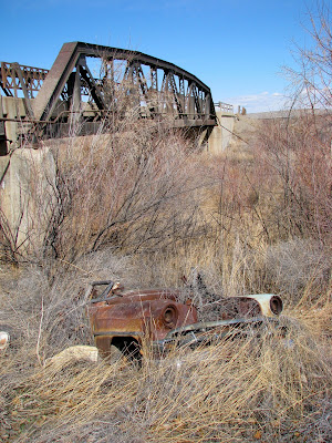
Winchester is north of Thermop on US-20, just after you cross the county line into Washakie County--about 17.5 miles. US-20 goes around Winchester, but the road below used to be the main thoroughfare. The bridge is on the northeast end of this "census-designated place."
These shots were all taken today.


 For a satellite view, click here.
  The owner of the property informed me that this used to be the grocery store (below).
 This was the post office.
 To the right of the grocery store was a gas station and a small motel, but it burned down in the 1950s and was eventually replaced by the building in the background (below).
 This was the schoolhouse.
 On the west side of Winchester is an oil tank farm.
 To see more photographs of mailboxes, click on these links: mailboxes, parts 1, 2, 3, 4, 5, 6, 7.
If you follow the road southwest, about a mile, you come to the mailbox and sign below where a road goes south over the railroad tracks and leads to a dam. It's a private road, but the superintendent of the Upper Hanover Irrigation District invited us to take a look.  To the left of the cattle guard it reads, "SPORTSMEN WELCOME PERMISSION REQUIRED"
 If you want to see more shots of cattle guards, click here.
I took this shot of Winchester (below) standing at the location above.
 The dam is primarily used to divert water to an irrigation canal during the growing season.
 Looking downstream:
 Looking upstream:
 The superintendent lives in the house below. For a satellite view, click here.
 This is a look downstream (west) toward the dam. The Bighorn river runs in a northerly direction, but this is one of the bends it takes.
 The photo below is looking south.
 In the distance is Winchester.
 Below is the western entrance, off of US-20.
 See also Winchester, WY, part 2.

No comments:
Post a Comment